Circular walks around Montacute
Walks around Montacute
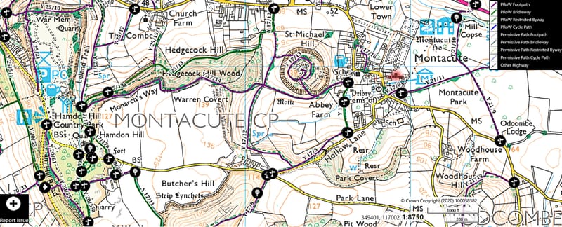
According to South Somerset.gov website there are over 9000 public rights of way in the county totalling 3808 miles (6129 km). There are long distance footpaths through the surrounding area such as the Leland Trail, the Liberty Trail and the River Parrett Trail and the area around Montacute has lots of footpaths and green lanes (see screenshot below from footpathmap.co.uk).
In the immediate area around Montacute the National Trust has some great walks signposted. Below I've included my favourite circular routes that can be taken around Montacute; the National Trust footpath routes can change to minimise erosion, if in doubt follow their signposted tracks. Please keep to the proper footpaths with dogs on leads where directed and please pick up after them; where dogs run around, so do children!

The screenshot below (from footpathmap.co.uk) shows footpaths in red and permissive paths in dotted red lines
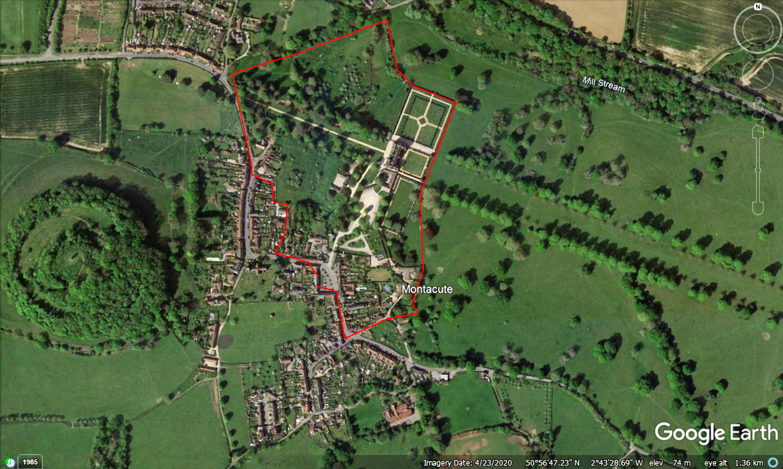
Montacute Park and the West Drive
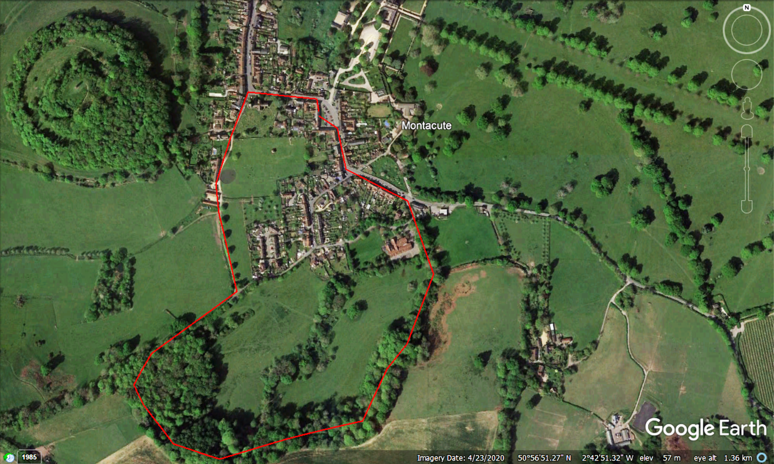
The route shown below (marked up in red and screenshotted from Google Earth) shows a 1 mile walk that can be taken starting in the Borough (opposite the Phelips Arms and the entrance to Montacute House), and going north through the village in the direction of the Tower. This map shows the route through Wash Lane but it is just as nice to walk up to the Kings Arms Inn (http://thekingsarmsinn.co.uk/) and St Catherine's Church, then walk north along Bishopston. It passes the west of Montacute House with an iconic view down the West Drive. Go into the field on the corner and follow the footpath down to the bottom of the park, then walk back up around the formal gardens (see if you can spot Montacute House's ice house on the first corner of the gardens!) Continue along the east aspect of the house, passing the East Drive with its stunning avenue of trees. Follow the footpath around to emerge into Back Lane; when you come out of Back Lane turn right to head back to the Borough, passing Montacute's beautiful Baptist Church and then the Toy Museum (currently closed) on your right.
The National Trust currently has this route waymarked in the opposite direction through Montacute Park as part of their 'St Michael's Hill' walk; keep to their paths where possible.
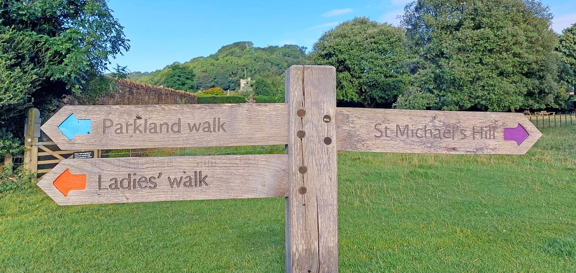
Ladies Walk
A slightly longer walk of 1 and a 1/4 miles can be taken from the Borough going south-east through the village and then up through Ladies Walk.
Walk from the Borough out of the village so the Phelips Arms is on your left. The late 19th-century Baptist Church with its pretty frontage is tucked away on the left. Go towards the Post Office then follow the road round to the left. Before you get to the garage turn right towards All Saints Church School. Where the drive curves right continue straight ahead into Ladies Walk.
This walk marks the south-east boundary of the Park granted to Montacute Priory by King John in 1192. In late spring the beech woods are carpeted with a haze of bluebells, punctuated with pretty white wood anemones. There is a bench at the top of the woods where you can catch your breath and enjoy a fantastic view of the village.
The path is signposted by the National Trust and comes out from the woods into a field, from here go left to exit onto Hollow Lane. Further up, this lane becomes a typical South Somerset sandstone ravine; a glorious sight when the sun is shining on it, but please be cautious if you walk up as there are no pavements down the sides of the road.
Go straight across Hollow Lane and return to the village via the footpath past Abbey Farmhouse. This was once the gatehouse for the Cluniac Priory site; although the priory was established around 1100, the gatehouse in its current form was probably a late addition to the site, built only a few years before Henry VIII dissolved the monasteries in the 1530’s.
Opposite the farm buildings is the priory fishpond; from here if you look past the 17th century dovecote you get another view of the fabulous window of the Baptist Church on South Street.
Continue towards St Catherine's Church, noting the castellated former church school building (now a private house) on your left. Turn right down Middle Street towards the visitor entrance of Montacute House and the Borough.
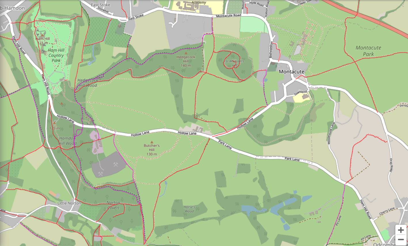
St Michael's Hill and Ham Hill
A longer circular route of about 4 miles takes in both St Michael's Hill with its prominent Tower and also Ham Hill, where the local stone is quarried. Again starting and finishing at the Borough, the nicest route to take is up through the village towards St Catherine's Church, left towards Abbey Farmhouse, then follow the footpath signs to go in front of the farmhouse towards St Michael's Hill. Skirt round the south of St Michael's Hill then cross to the south-west corner of the field towards the woods ahead of you, there is a stile into the route across the top of Hedgecock Hill. Follow this route all the way to Ham Hill Country park. Once on Ham Hill there's a fantastic view to the west from the lay-by where the ice-cream van often parks. Continue to the north of the Hill to admire the view from the War Memorial. From here walk clockwise around the north spur of the Hill, past the Prince of Wales. On the corner of the road by the pub go down the flight of steps and take the lower route home through the woods. When you come out of the woods follow the lane round to come into the field below St Michael's Hill. Head towards the gate and continue up to the Tower. Once you have admired the views from the Tower you can head back down the same route, or descend the steeper path on the south side of St Michael's Hill. Continue back down past Abbey farm, then back though the village.

Ham Hill and Witcombe Valley
This next route is also about 4 miles and starts off in the same direction as above to get to Ham Hill, but then follows the route down from the Hill down the road to the picturesque Mill in Little Norton (you will need to take a detour to the left in the village to see the Mill). From here walk back east along the road (past a spring on your left, known locally as Tinkers Bubble), until you come to a field gate on your left. Walk up though the valley; this valley was the site of the Medieval village of Witcombe, a village which was deserted in the 1600's. From the top of the valley walk right along the road then left down Hollow Lane; this is worth a few photos but watch out as there are no footpaths! The route marked on the Google Earth screenshot below takes you back through Townsend and past the Post Office, Baptist Church and Toy Museum in South Street to return to the Borough.

Staying in Montacute
If you're looking for somewhere to stay while walking in the area, I let out a small, Grade II listed cottage in the centre of Montacute, in the Borough just across from the visitor entrance to Montacute House. The cottage sleeps four (one double room and one twin), with a kitchen, dining room, sitting room, bathroom, and an extra downstairs loo. It's set back from the road, with a south-west facing garden laid to flower borders and a patio outside the kitchen — a lovely spot to sit in the afternoon and evening sun, with views up to Montacute Tower. The cottage is simply furnished and set up for adults looking for a quiet break. These local walks begin on the doorstep! The garage on the edge of the village sells essentials like milk and bread, and the Post Office, round the corner, stocks local crafts. If you’re interested, booking is through Sykes Cottages.
Montacute flora and fauna
Montacute is typical of ‘bocage’ countryside, with sunken lanes, thick hedgerows, and mature trees. The hedges are often full of brambles and ivy, which provide homes for birds such as robins, goldfinches, chaffinches, bullfinches, blue tits, great tits, long-tailed tits, wrens, thrushes, and blackbirds. Migratory redwings and fieldfares feed on the berries. In Montacute Park, ancient oak, lime, and chestnut trees are home to nuthatches, tree-creepers, green woodpeckers, and great-spotted woodpeckers. Many bat species have been seen in the National Trust parkland, along with buzzards, sparrowhawks, kestrels, and kites. Roe deer are sometimes seen in Ladies Walk, and badger setts are found in the woods. Primroses and violets bloom in early spring, while bluebells flower in Ladies Walk towards the end of April. Ivy-leaved toadflax and maidenhair spleenwort grow in the hamstone walls around the village. You may also spot the multi-petalled ‘Montacute celandine’. Wild redcurrant and red campion grow on St Michael’s Hill, and when wild garlic is in full bloom, the scent can sometimes be carried into the village on a gentle breeze.