Ham Hill
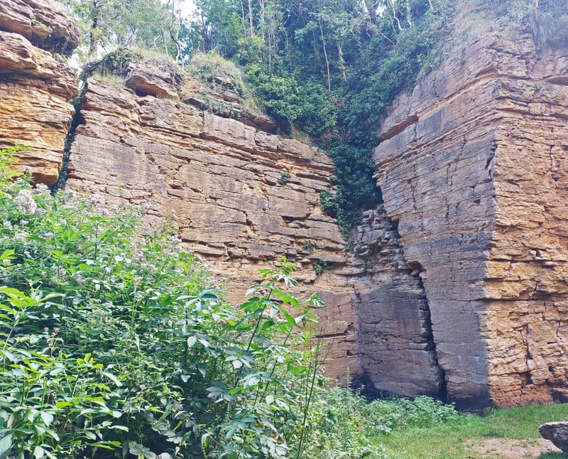
Image (copyright Rebecca Bosson 2021) shows Deep Quarry at Ham Hill
Ham Hill is an SSSI and a Scheduled Ancient Monument. A layout of Ham Hill is given in this Map of Ham Hill and in the Quick Guide to Ham Hill published by on the Visit South Somerset website. Montacute is to the east of the hill; to the north is Stoke-sub-Hamdon and to the south is Norton-sub-Hamdon.
Where does the name 'Ham Hill' come from?
The name 'Ham' could derive either from the old English 'ham' meaning "homestead, village, manor, estate" or from old English 'hamm', meaning "enclosure, land hemmed by water or marsh or higher ground, land in a riverbend, rivermeadow, promontory"; either would fit the location. The name Stoke-sub-Hamdon could be compounded from 'don', old English for hill, and Stoke, from Stoc, meaning "place, outlying farmstead or hamlet, secondary or dependent settlement". (So Stoke-sub-Hamdon could mean hamlet-under-hamlet hill?) However, in the 1914 publication 'The place-names of Somerset', James Hill suggests the derivation of Hamdon may derive from John de Elmedone (Witness to charter 211 of the Montacute Cartulary in 'The Two Cartularies...' in which "R. Lovell, lord of Castel Cari, quits claim to the prior and convent of Montacute....". He also says "Stok Suth Amel-don and Stoket or E. Stoke are named in the Lay Subsidies of Edward III". He concludes "Ham-done is therefore a corruption, and abbreviation of, a personal name, like Emborough, which is also spelt Amel-bergh. This name is probably Hamelin de Cornubia,a signatory of an early document relating to Hamedon. This name becomes Hampden. It has been derived from Afondon, the hill-fort by the river."
The Old Chapel on Ham Hill
In A History of the County of Somerset: Volume 3 it says that in 1535 there was a chapel on Ham Hill dedicated to the Holy Cross; oblations offered there belonged to Montacute priory as owner of Montacute rectory. It probably stood near the Prince of Wales inn, where a piece of land was called Hanging Chapple in 1666, and Ham Chapel in 1840. Its connection with Montacute may suggest an association with the fair on Ham Hill given by the count of Mortain to Montacute priory c. 1102.
Ham Hill in 1633
In 1633 Thomas Gerard of Trent described Ham Hill as follows: Having thus farr coasted Hamden hill, I will desire your company to the topp of it, where besides the pleasure of the prospect, I hope to find something that may countervaile your pains. For you shall see on the north side where wee rise up from Stoke unto it, the footings of that Fort I have before spoken of; on the south, the goodlyest quarry of freestone that ever I saw, which for beautie largenesse, lasting and antiquitie I presume gives place to none. I am sure in the western parts the antiquity is sufficiently shewen, in that all our ancient Castells, Churches and Mansion houses both here, in Dorsett, and a part of Devonshire, shewe it; the beautie is both in the Couller, being a faire yellowe or oker couller, for amongst it is found in vaines much okar with which they wash over and clesne foule stones; and largenesse, for out of it they take stones of what bigness the workmen please, and I never sawe any quarry to come near this in Couller and goodness save one within two miles of Northampton the principall towne of North'tonshire; for lasting, if it be out of a good bedd, it endures fire water and all things else. The masons here have a pretty kind of common- wealth; they have their courtes in which all trespasses against each other are judicially tried; and the Quarreys themselves seeme rather little parishes then quarryes, soe many buildings have they under the vast workes to shelter themselves in wet weather, and their wrought stones in winter. Whence this hill tooke the name of Hamden I cannot tell; you may remember but erst while a Record called it Hamelden, but I believe it is that Hamamdun1 which the Saxon king Etheldred in the yeare of grace 987 gave to the Abbey of Glaston, and since the dissolution it is come by the Duke of Somersett unto the Earle of Hertford, who also is Lord of Norton called under Hamden, which formerly acknowledged the Delapooles Earles of Suffolke owners of it.
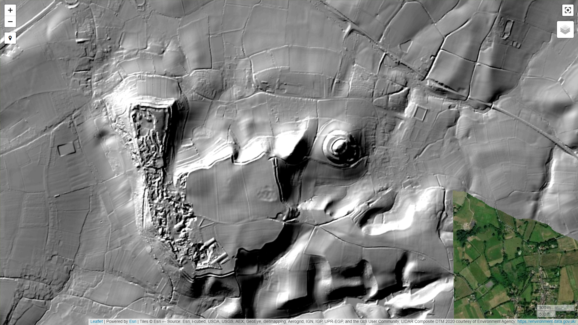
Aerial views of Ham Hill
This Lidar Map (also available through ArchiUK) clearly shows the extent of the hillfort plateau, the comparable area from Google Earth (outlined in yellow) is shown below:

Ham Hill Geology
The Hillfort is a natural feature that has been fortified. For information about the underlying geology see Ham Hill Geology Trail (A self guided trail) (PDF) published by South Somerset Council and A Geological Guide to Ham Hill by Hugh Prudden (PDF) (Open University, https://ougs.org/files/wsx/reports/Ham_Hill-4-7-15.pdf). The British Geological Survey gives an overview of Ham Hill's geology and has links to further information, including geological map viewers.
Hamstone may have been quarried from the hill since Roman times, and the quarry was most prosperous in the 15th to 17th centuries. Hamstone is still quarried on the southern end of the hill.
Ham Hill History
The Somerset Historic Environment Records relating to Ham Hill are extensive and document the occupation of the Hill from Paleolithic to modern times. There are some interesting aerial photos on the Cambridge Air Photos website
There is good evidence of prehistoric settlers at Ham Hill. Aston and Burrow (The Archeology of Somerset, 1982) and more recent excavations record an upper paleolithic hand-axe (13,000-10,000 BC), Mesolithic worked flints (9,600-4,000 BCE), Neolithic pits, stone axes and flints (4,000-2,500 BCE) , late Bronze Age pottery, copper alloy tools and ditches from the north end of the hill (2,500 to 800 BCE), and Iron Age (800 BCE to 43 AD) features throughout the area (mostly mid to late Iron Age) including crouched inhumations and disarticulated human remains (Excavations at Ham Hill in 2011, 2012 and 2013, summarised in 'Excavations at Ham Hill, Somerset 2011-2013: Post-Excavation Assessment' (Britain et al. 2015). A more recent survey in 2021 prior to further quarrying found very little to add to this, see Ham & Doulting Stone Quarry, Ham Hill, Somerset - An archeological investigation Brittain & Chaplin 2022 (please note this website often goes down!). Iron Age iron currency bars have been found on Ham Hill, and Bronze Age coins from Ham Hill are from the Celtic Durotriges tribe (Seaby 1949, https://www.jstor.org/stable/42661417). Ham Hill was occupied by them from 800 BC to the time of the Roman invasion, although most other Celtic tribes had stopped using hillforts by this time.
Roman Ham Hill
Many sporadic finds of Roman artefacts have been made over the years, including scales of armour, jewellery, buckles, potsherds and coins from the reign of Augustus (27BC to 14AD) through to the reign of Theodosius (379 to 395AD). However their locations have not been catalogued adequately to give a good picture of how Ham Hill was used in Roman times (VCH vol 1); see also my page on Roman Montacute.
R. Hensleigh Walter
Some interesting articles about Ham Hill were published in the beginning of the 20th century by R. Hensleigh Walter in the Proceedings of the Somerset Archaeological and Natural History Society (SANHS); born in 1862, he followed his grandfather and father in collecting antiquities from Ham Hill. He lived in Stoke sub Hamdon, where he had a small museum in his home. This 'Walter' collection was donated to the Somerset Museum. Walter, R, Hamdon Hill, Part II, Vol 4, (1853), pp 78-90
Notes on the Castle of Stoke-sub-Hamdon
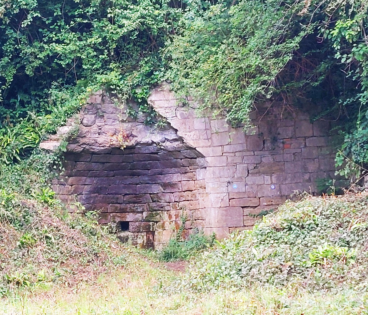
Lime kilns on Ham Hill
Lime kilns are used to burn limestones such as hamstone, to produce 'quicklime' (calcium oxide) for use in limewash, plaster and mortar. The remains of a lime kiln dating from the 1900s can be seen near the Lime Kiln carpark (photo below), there have probably been many kilns in use across the hill and a map in R. Walter's 1853 article on Ham Hill places one on the easterly prominence of Butchers Hill.