St Michael's Hill and Montacute Tower
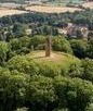
Image of St Michael's Hill from a National Trust publication
St Michael's Hill is also referred to using the contraction 'Mileshill'. Today, Edward Phelips's 1760 hamstone tower stands on top of the hill where previously the Normans had built their Castle. Ham Hill, Hedgecock Hill and St Michael's Hill border the southern edge of the Somerset levels (see map at bottom of page), and it is tempting to suspect that, just as Ham Hill has evidence of Stone Age man, they could also have hunted or even occupied St Michael's Hill.
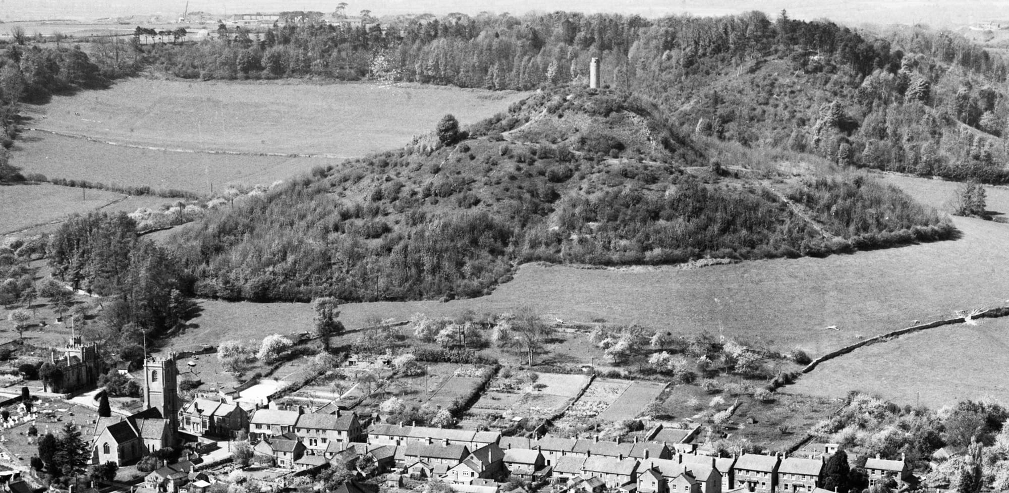
"Sweet Michael's, loveliest of the hills around, with beauty clad with constant verdure crown'd!" (Thomas Shoel, Mileshill, 1821). Clearly this line was written when the hill was wooded, and not in one of the phases when the trees were stripped back. The photo below was taken in 1948, a few years after the hill had been cleared of trees. Montacute village is in the foreground. The National Trust is again removing some of the taller trees, to reduce damage to the structure and to promote undergrowth for diversification of species. Hopefully they won't go this far again!
A tunnel between the tower, the priory and the church?
Anyone who grew up in Montacute will know the stories of a secret tunnel between Montacute Priory and Montacute Tower, and the spiral staircase in the tower appears to descend below the floor level but is then blocked. So was there a tunnel? Montacute Tower stands on the footings of the old chapel which was destroyed by the mid 1600's; this chapel is said to have been built on top of the dungeon of the Norman castle which was built on the hill by 1068. Montacute Priory was disbanded by 1560 but the tower wasn't built until 1760. Neither Leland's description from the mid 1500's nor Thomas Gerard's description from the mid 1600's mention a tunnel, and there is nothing in the records of the Phelipses who built the tower, so a tunnel seems unlikely. Or could there have been a tunnel between the Priory and the Church? Who knows...
The History of St Michael's Hill
Montacute was thought to have been used by Saxons, and The Waltham Chronicle (ed. Watkiss L and Chibnall M 1994) tells how a miraculous Holy Cross was found at the summit of St Michael's Hill in around 1015-1035AD (see my page on Montacute's Legend of the Holy Cross). It is not clear if buildings stood on the hill prior to the Norman conquest of 1066. After 1066 William the Conqueror gave Montacute to his half-brother Robert, Count of Mortain, who constructed a motte and bailey castle on the hill “to overawe the district around” (see The Two Cartularies of the Augustinian Priory of Bruton and the Cluniac Priory of Montacute in the County of Somerset; The Somerset Record Society, 1894). The castle was completed by 1068. There was a significant revolt there against the Normans in 1068/69, possibly because the hill was a significant religious site if the story of the Holy Cross is to be believed. Geoffrey de Montbray (Bishop of Coutances) successfully led the Norman defence and the dead were buried in Under Warren, to the south-west of the hill. After Robert's death ownership passed on to Robert's son, William, Count of Mortain, and in 1102 he gave it to his newly-founded Cluniac priory in the village (A P Baggs, R J E Bush and Margaret Tomlinson, 'Parishes: Montacute', in A History of the County of Somerset: Volume 3, ed. R W Dunning (London, 1974), pp. 210-224).
The Structure of the Hill
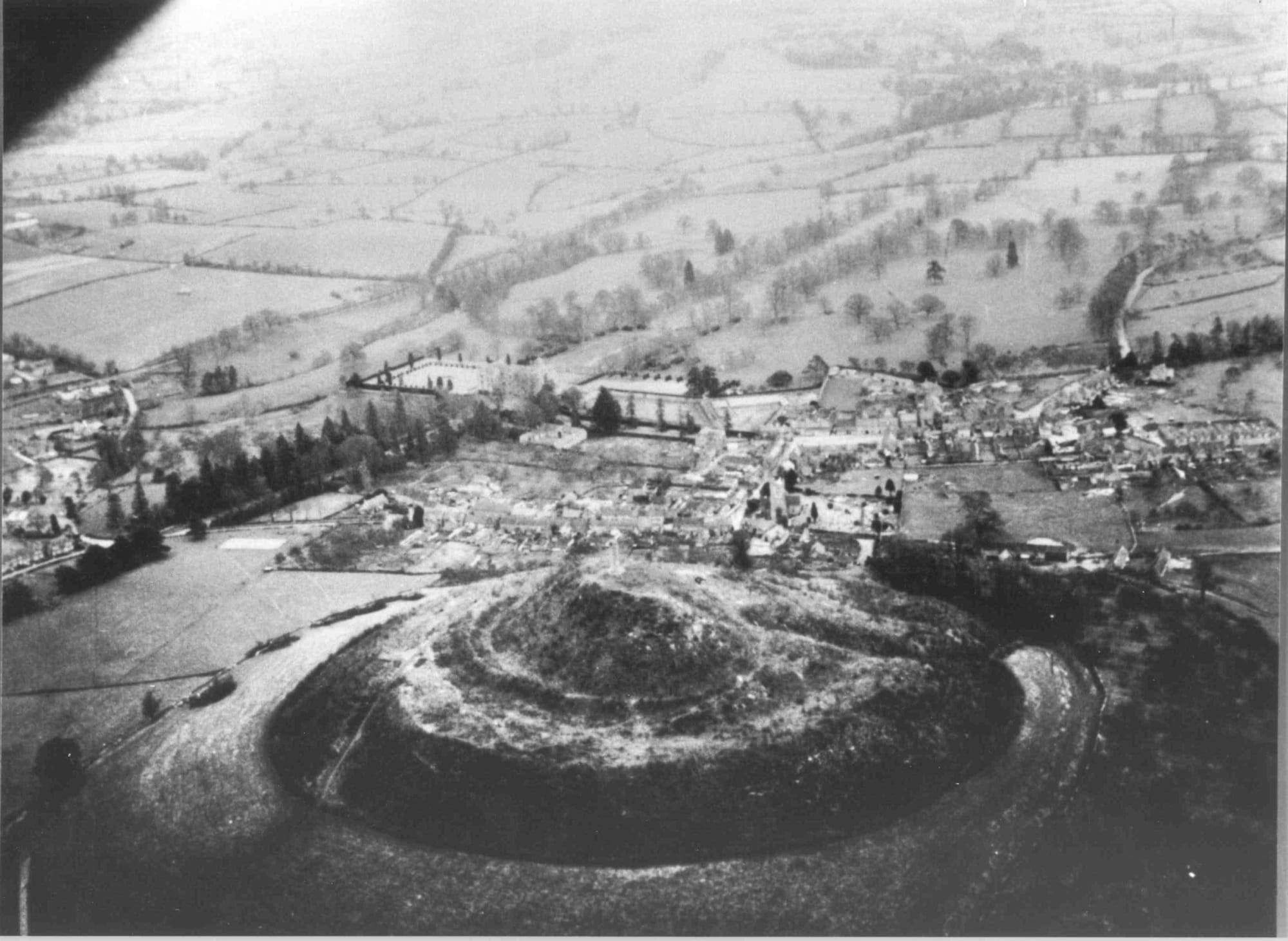
St Michael's Hill is a scheduled monument and its construction is described in its Historic England listing and on the Somerset Heritage website. The image below shows its distinctive motte and bailey shape. This photograph was obtained from https://archaeologynationaltrustsw.wordpress.com/2013/11/03/st-michaels-hill-montacute/ on 21.11.2021; it is an aerial view of St Michael's Hill taken in 1940, shortly after all the trees had been chopped down. Montacute House can be seen beyond the hill and slightly to the left.
If you click on this link you will see another image, on the 'Britain From Above' website, showing the hill from the south-east in 1948. The return of scrub makes the shape of the hill much more difficult to see. If you search the map view on the Britain from Above website you will find photos from 1948 but also some from 1930 and one from 1928.
National Trust archeologists interpretation of the site

Archeologists for the National Trust came up with this great interpretation of how St Michael's Hill might have looked in early medieval times. In his March 2023 blog, Martin Papworth describes how the team used LiDAR imaging to show significant features; it is interesting that the proposed entrance route leads to the buildings behind Abbey Farmhouse, which was previously the entrance gatehouse for the Priory.
The Chapel on the Hill dedicated to St Michael
By 1102 there was a Chapel on the hill dedicated to St. Michael; it may have been built by Montacute Cluniac Priory (Somerset Historic Environment Record 54294); it was still in use in 1315, and stood on the castle mound, reached by a flight of stone steps ('Parishes: Montacute', in A History of the County of Somerset: Volume 3). I have not seen the original documents, but the Tintinhull Local History website notes that Cotton MS Julius F. vi records how Reginald, Chancellor to King Henry I (1100–1135), enlarged the priory with new buildings and additional possessions. It also states that he converted the remains of Earl Mortain’s castle on the Mount into a chapel “roofed all wyth stone, carved verye artyfycyallye, and dedicated to St. Mychell, vawted within with stayers made with stone from the fote of the hyll to the toppe.” I don't know the details or date of the MS referenced.
In 1246 the king granted the priory an annual three-day fair 'at their chapel of St Michael of Montacute' (the precise location is unclear). (http://www.gatehouse-gazetteer.info/). In 1518–19 the churchwardens of Tintinhull paid for two loads of stone from it ('Parishes: Montacute', in A History of the County of Somerset: Volume 3). It may have lasted until 1630 (ref. archaeologynationaltrustsw website, pages on St Michael's Hill, Montacute). Leland c. 1542 records that the castle had been used to build the Priory, and the Chapel was built on top of the old castle dungeon:
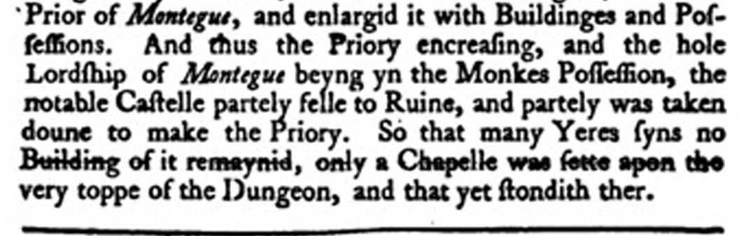
Thomas Gerard of Trent, writing in 1633, records that he had seen the ruins of the chapel: "I have scene the ruines and soe may any else if they will for they remaine untill this daye, which was a Chapell built on the topp of the hill where the Castle stood by some Priour of this House and dedicated to St. Michaell".
The 'Stonyng Door' in Tintinhull's churchyard appears to have used stone from the castle (J. B. Hyson, SANHS 32, 1886, p73)
A small trench opened on St. Michael’s Hill in 1989 showed the presence of masonry walls but these probably belonged this medieval chapel (Somerset EUS; an archaeological assessment of Montacute; Richardson 2003.)
Description of St Michaels Mount published in the Gentleman's Magazine in 1817
Note this description below gives interesting measurements for the tower; the height of 60 ft topped by a fifty foot flagstaff and flying a fifty-six yards in the air seems exaggerated. Historic England gives the tower height as 12 m (39.4 ft) and diameter as 3 m.
Embellished with a Perspective View of the Mount called MONTACUTE, or ST. MICHAEL'S HILL, situated in the parish of MONTACUTE, in SOMERSETSHIRE. Dec 4
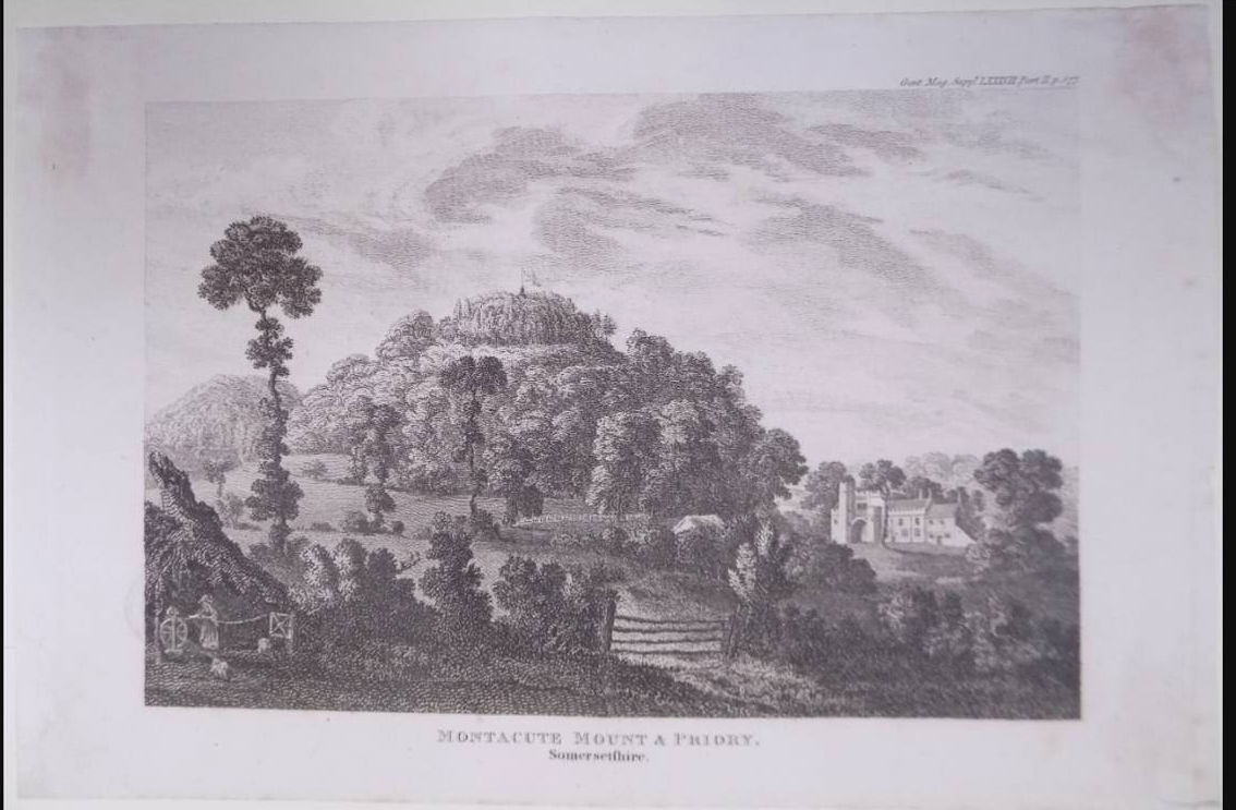
Mr. URBAN, I send you a view of that noble Mount called Montacute and St Michael’s Hill (see the Plate), situate the parish of Montacute, in Somersetshire; the base of which contains near 20 acres. it rises boldly out of the plain, and bears the appearance of a Cardinal's hat.
"Its form is conical, and its ascent very steep, the top terminating in a flat area of half an acre, whereon stands a round tower sixty feet in height, and crowned with an open ballustrade. On this tower is a flag staff fifty feet high, on which a flag is occasionally displayed floating fifty-six yards in the air, and exhibiting a grand and picturesque appearance. The summit of the tower being so highly elevated above the level of the central part of the county, affords a rich and extensive prospect, extending Westward to the hills below Minehead and Blackdown, in Devonshire; and North-eastward over Taunton, Quantock Hills, Bridgwater bay, the Channel, and coast of Wales. To the North, Brent Knoll, the whole range of Mendip, city of Wells, and Glastonbury-Torr, Eastward, Creche and Knowl hills, Alfred's-tower At Stourton, and high lands about Shaftesbury; and Southward, over the Dorsetshire hills to Lambert’s castle near Lyme; the whole a circle of above three hundred miles, in which, on a clear day, eighty churches are distinguishable. This hill is planted from bottom to top with oaks, elms, firs, and sycamores, the intermingled foliage of which (especially in the autumnal season) forms a rich and beautifully tinted scenery*.”
Near this Mount are two other eminences, called Hedgecock Hill and Hamden Hill: the latter of which has been remarkable for many ages for its freestone quarries, of which most of the churches in the neighbourhood are built.
At the foot of the Mount was founded, about the year 1091, by William Earl of Morton, a priory of Black Cluniac Monks, which was surrendered to Henry VIll. in 1539. The remains are partly represented in the Plate.
The site, &c. of the priory was granted to Sir William Petre, and sold by him to Mr. Robert Freke; of whom it was soon after purchased by the family of Phelips, who at the time possessed some other parts of the manor; and is now the property of John Phelips, esq.
The parish of Montacute is situate four miles South-west of Ivelchester and is in the hundred of Tintinhull. It is divided into three tithings, viz. Bishopston, Hyde, and Widcombe besides which there is a small hamlet called Thorn. The tithing od Bishopston comprehends the town of Montacute, which consists of three streets, forming nearly the letter H; wherein, according to the Return to Parliament, there were, in 1811, 8 houses building, 2 uninhabited, and 165 inhabited by 188 families (80 of which were employed in agriculture and 102 in trade, &c.), consisting of 400 males and 457 females: total 857. The Church, situate immediately under the Mount, is dedicated to St. Catherine, and consists of a nave, chancel, and two side ailes; at the West end is an embattled tower. In the church are several stately monuments to the family of Phelips.
Nearly adjoining is the large and noble Mansion-house, built in the reign of Elizabeth, by Sir Edward Phelips, knt. the Queen’s Serjeant, third son of Sir Thomas Phelips of Barrington (at which place the family had previously resided), who settled his family at Montacute, where they have been ever since. The house is 92 feet in height, and a remarkable gallery runs the whole length of the building to the extent of 189 feet.
Yours, &c.
B. N.
Mr.
* Collinson's Somerset, III p. 309.
GENT. Mag. Suppl. LXXXVII PART II
The present-day Tower on the Hill
The Tower is a folly, built by the Phelipses in 1760. It is a grade II listed building and the Historic England listing (ref. 1057255) details the construction and includes the following information:
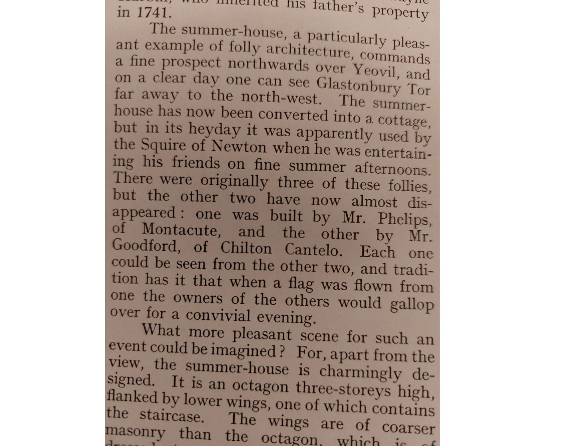
"Folly, used as signal tower. 1760. Greek inscription over the doorway and the initials 'K.P. 1760' (but Edward Phelips was the likely builder). The hill was the site of a Norman Castle, mostly demolished to build the Priory of Montacute: St. Michael's Chapel, first recorded 1102, survived at least until the mid C17; its site now occupied by the tower, which was used as a signal tower to Mr. Swayne Harbin at Newton Surmaville (using the Round House, Item 2/26 Barwick C.P., q.v) and Mr. Goodford, of Chilton Cantelo." This reference to signalling comes from a Country Life article of 5th September 1952 an article on Newton Surmaville (p676-679) however there is an inconsistency, as the article (excerpt below) says the other two signal towers have disappeared? Today the Round House still stands on Summerhouse Hill just south of Yeovil, although it is actually octagonal.
The Greek inscription over the doorway of the tower once read "(?) 1760 Περίσκοπειν" (periscope) but is barely legible now:

The photo below is from the 1900s, by Alfred William ("Toggy") Chant of Stoke Under Ham, and appears to show some sort of signalling apparatus on top of the tower, although this could be a lightning conductor? (Thanks to NC for finding it!) There is also a hand-drawn illustration in The Powys Journal 7 (1997): p116 (http://www.jstor.org/stable/26106493) ("from a sketchbook started in 1895") which appears to shows a similar sort of apparatus on top of the Tower.
Was there a 'Gothick Folly' on the hill before the tower was built in 1760?
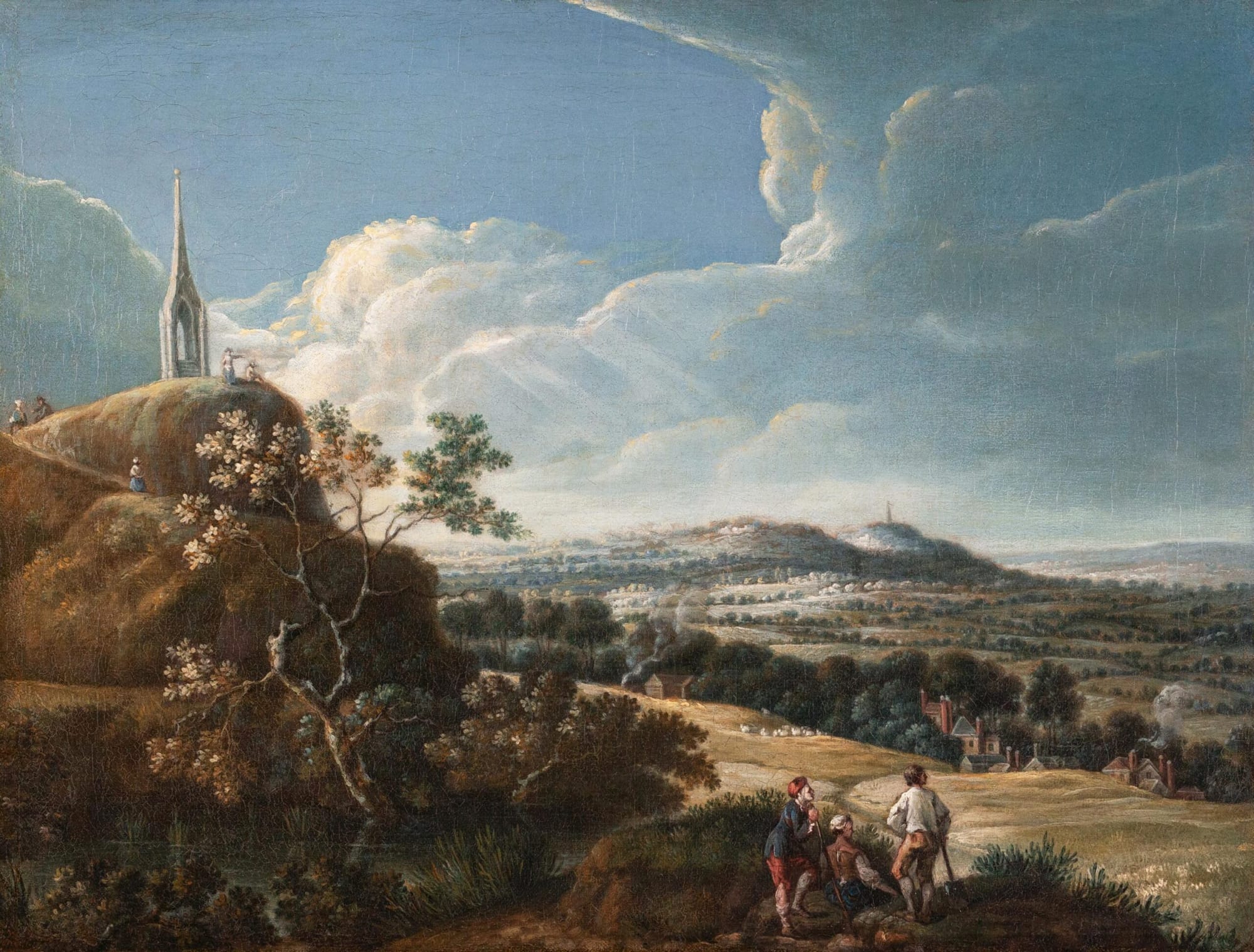
Picture above: (ATTRIBUTED TO) Coplestone Warre BAMPFYLDE (1720 - 1791) Somerset; a view from the garden of Montacute House with St Michael's Hill in the foreground and Glastonbury Tor in the distance. As sold by Abbott and Holder; The Gothick folly on St Michael's Hill (previously unrecorded). Oil on canvas. c.1755 before the building of St Michael's Hill Tower in 1760. 18.75 x 24.5 inches. Thanks to AM and NM for finding this gem!
Information from the Abbott and Holder website:
The stone tower that stands on St Michael's Hill today was built by Edward Phelips V (1725-1797) in 1760. The Gothick folly shown here is previously unrecorded. Edward Phelips V had come to his majority in 1750 and many of his famous improvements to Montacute House and the Estate were made in the 1760s and beyond. The Gothick folly might have been put up as an affordable, temporary structure. Or perhaps it was an idea that was never built, the design being usurped by the tower scheme; paintings like this were often made as part of a Set depicting a house and estate, and just as often showed how things were intended to look, as they did how things actually were. As was typical, the unidentified artist has taken some liberty with the topography, bringing Glastonbury and the (enlarged) Tor into closer view. But this is not simply artistic license. A figure on top of St Michael's Hill gestures towards Glastonbury Tor and sunlight breaks through the clouds highlighting Glastonbury and Somerton (the hill in the middle distance and the ancient capital of Wessex). There are deep historical, religious and political associations between the St Michael's Hill, Somerton and Glastonbury sites. These were well known to Phelips and were at the heart of his ancestor's reason for choosing this site for the house. It is entirely natural that a painting of the Estate should celebrate this. Please contact the gallery if you would like further information.
Views of the Tower
The following photograph (early 1950's?) of the Tower from the Historic England website (accessed 21.11.2021), viewed from Middle Street, shows how imposing the Tower is:
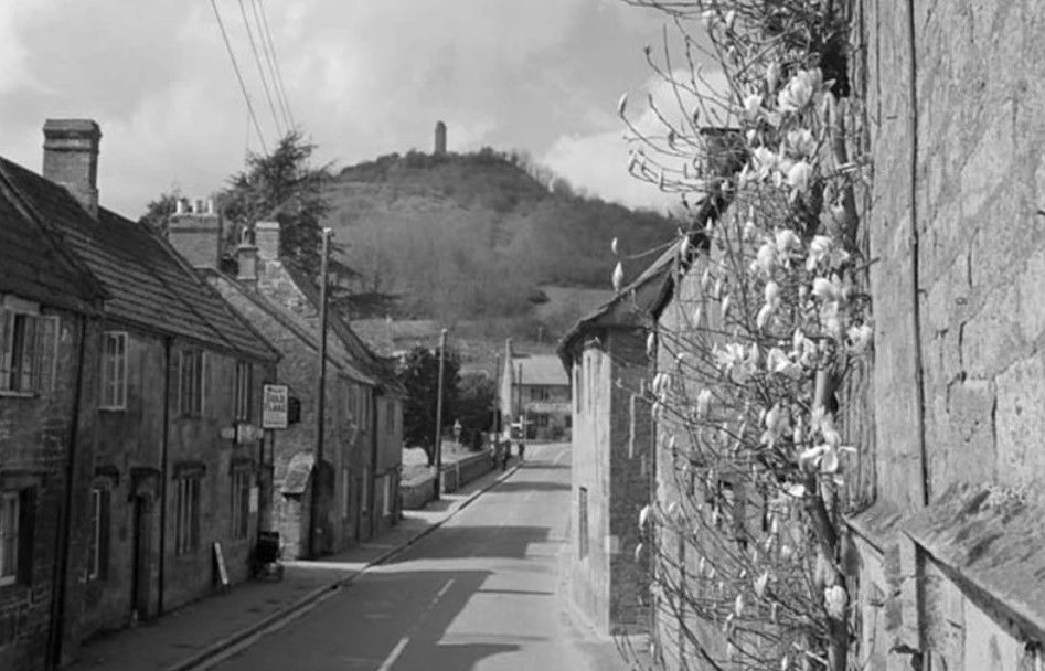
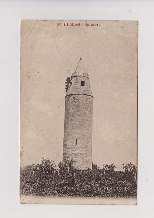
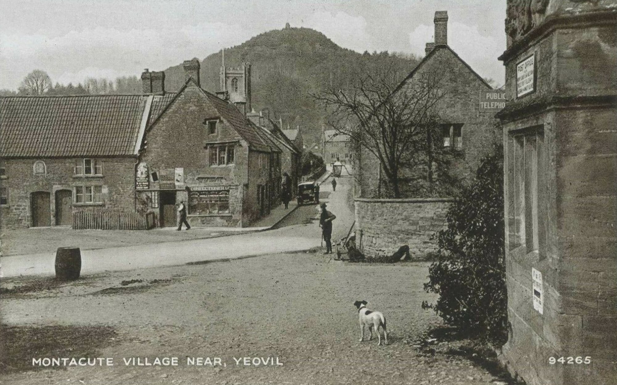
The image below, captured c.1925 and used on a postcard, also views the Tower from Middle Street:
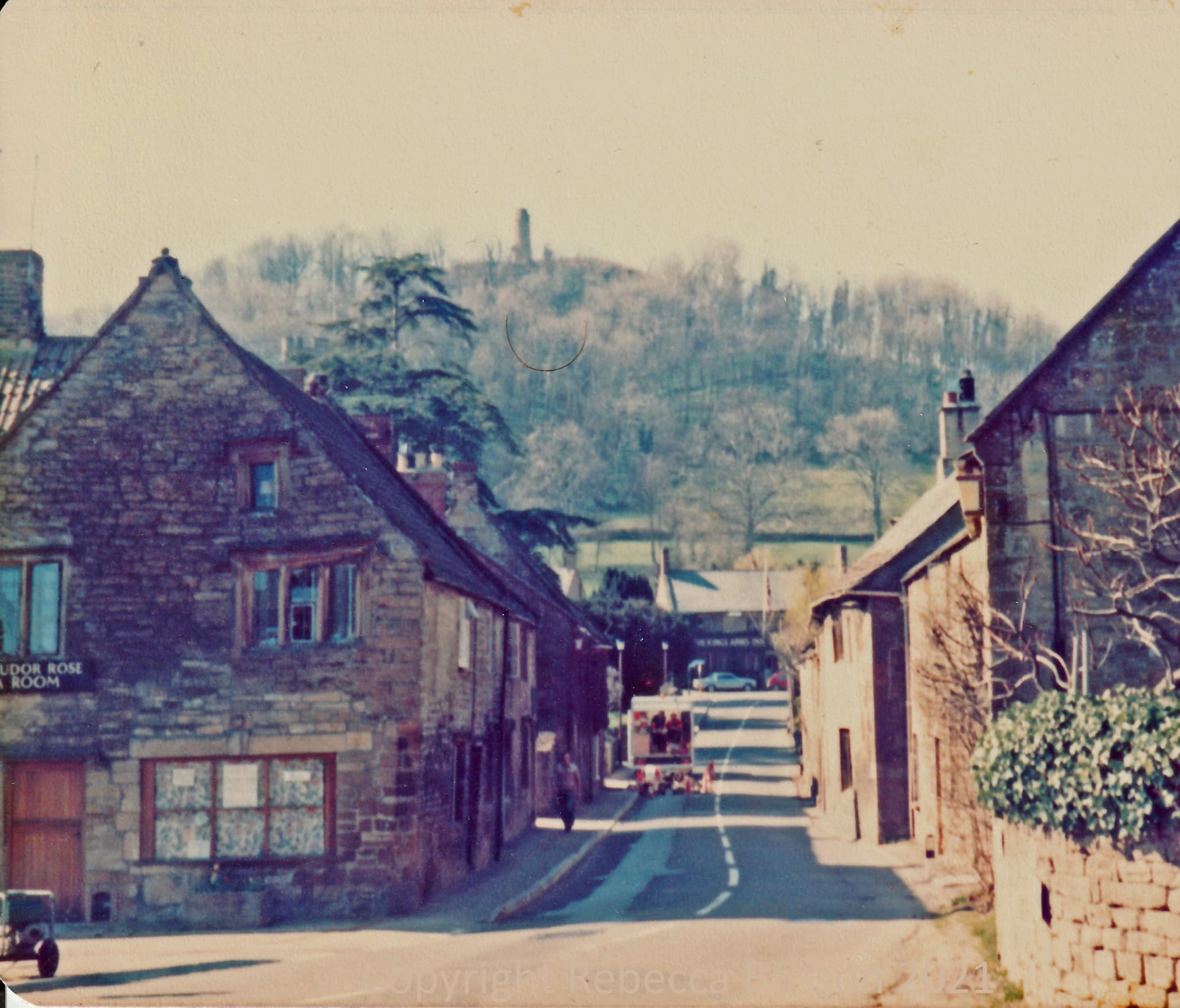
And below, the same view again, this time taken in c.1977 (copyright Rebecca Bosson, please credit if you use this photo):
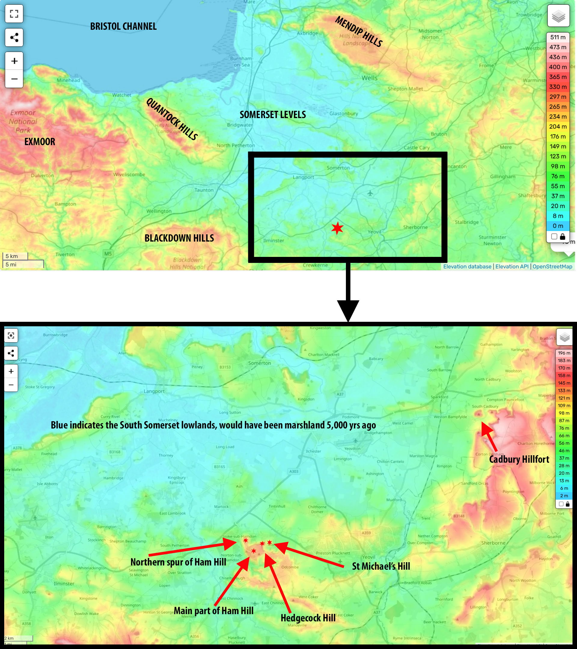
Below, map showing the location of St Michael's Hill, Hedgecock Hill and Ham Hill in relation to the Somerset levels.